4.1.1. Climate across the study area
The Colca valley is located in the western cordillera of Andes in a semiarid climate that is cool and unpredictable. As a high altitude region of tropical latitude, diurnal temperature variation is more prominent than annual temperature variation (Denevan, et al. 1987;Troll 1968). Precipitation is highly seasonal, however, and it is changes in rainfall and availability of pasture that strongly influence the scheduling and intensity of pastoralism and dry land agriculture throughout the study area. The south-central Andes is a region south of 15° S latitude, outside of the Intertropical Convergence Zone, and precipitation is relatively unpredictable with high interannual variability because it results largely from the convection of humid air from the Amazon Basin to the east (Johnson 1976). The western slope of the Andes thus lies in a rain-shadow, and warm, dry winds from the east result in low average annual precipitation as one descends the western flanks of the Andes. In the ecotone that is the Upper Colca study area the herding economy thrives, because these communities can seasonally exploit the rich pasture lands and greater rainfall of the high puna while simultaneously interacting with the communities and products of the main Colca valley, communities to which they may have family linkages.
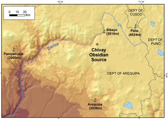
Of the major obsidian sources in the Andes, the Chivay obsidian source is the highest elevation source and the environmental conditions in the area during prehispanic procurement visits to the source are the subject of some speculation. Annual climatic variability under modern conditions at the Chivay source can be inferred from the relationship between altitude and temperature, known as the lapse rate, and this rate may be calculated using records from nearby meteorological stations. A mass of rising air will cool at the dry adiabatic lapse rate that is often estimated as 0.98° C per 100m of ascent for dry conditions, while the saturated adiabatic lapse rate is typically 0.5° - 0.6° C per 100m at dew point when temperatures are around 10°C (Adiabatic lapse rate 1999). This theoretical lapse rate may be compared with empirical temperature data reported by the ONERN environmental investigation, a regional study of the entire Majes-Colca drainage that preceding the construction of the Majes hydroelectric project. These data include mean monthly temperature records from meteorological stations at Pañe near the Colca headwaters, Sibayo on the northern edge of our Upper Colca study area, and the mid-altitude stations of Arequipa and Pampacolca (ONERN 1973;WMO 2006).
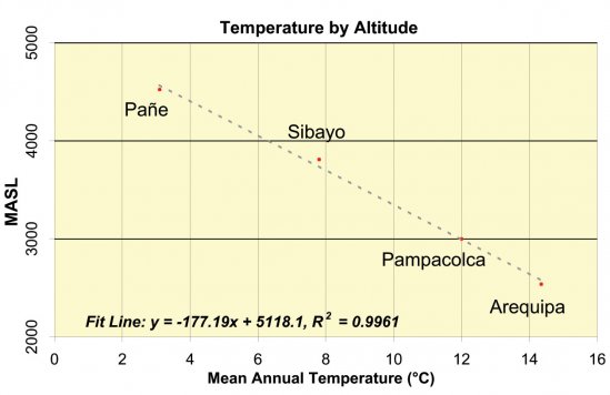
Figure 4-3. Temperature by Altitude at mid- and high-altitudeArequipa meteorological stations. All data from ONERN (1973) except Arequipa values from W.M.O. (2006). These data represent a lapse rate of -0.56°C per 100m of ascent.
These empirically-derived mean annual temperature values from the Arequipa sierra show a lapse rate of -0.56°C per 100m, which is in the range of the standard saturated adiabatic lapse rate of -0.5 to -0.6 per 100m, discussed above, from which can be inferred a mean annual temperature of 0.8°C at the Chivay obsidian source. Given the aridity of this region much of the year, the relatively low-slope (saturated) lapse rate is unexpected and the raw tabular data in the ONERN report suggests that a more detailed examination of the data will better allow the temperature variation at the Chivay obsidian source to be inferred.


