5.5.5. Attribute Forms
Aside from the site datum points and site boundary polygons, three dominant feature types characterized the archaeological data set in the mobile GIS. Each archaeological data type had an attribute form associated with it that recorded information appropriate for a given feature. Page One of the digital forms comprised a unique ID number generated from a script and a range of numbers for digital photos (JPEG files) documenting a feature.
|
(a) |
(b) |
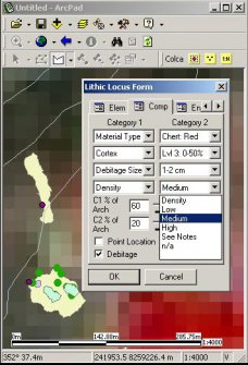
Figure 5-5. (a) Arcpad screen showing a large site with loci and points. (b) Example of page two of a lithic locus form in Arcpad showing Category 1 and Category 2 columns; in the background, two sites and contour lines are displayed on top of a 15m resolution ASTER satellite image.
Page Two of the attribute forms (Figure 5-5b) contained specific information about the feature type, such as Site, Locus, or Point information. The third page contained eight pull-down menus with environmental attributes for geology, exposure, and other local variables. These values were usually the same within a given site so that the values were "sticky"; they were stored in temporary memory between recording events, and the editable form was repopulated automatically unless a new site feature was being recorded. The final page contained a "Comments" field that accepted up to 255 characters and included a button that would open Pocket Word application with a text file named for the unique ID #, allowing the entry of additional notes if necessary. A link to a separate application that permitted MP3 compression of voice-based comments was available as well, but because the processor demands of sound encoding overly hampered the functionality of the Pocket PC for the GIS application, the feature went unused.


