5.5.3. Hardware configuration
Mobile GIS systems permit surveyors to attribute spatial locations with a variety of data types. Currently the GPS unit is the primary digital input into the mobile GIS and this permits the mapping of point, lines, and polygons delimiting archaeological features. In the GIS the spatial data is attributed and once post-processing is complete the new data joins the larger GIS database.
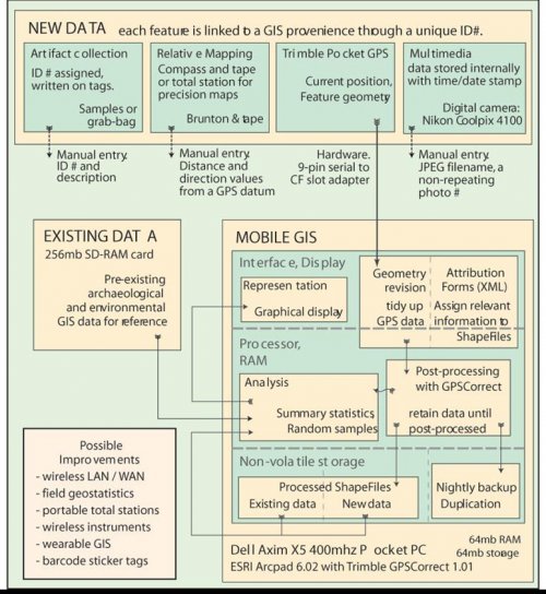
Figure5-4. Mobile GIS implementation with ESRI Arcpad 6. New data sources from external instruments are shown in the top row. Where post-processing is needed new data is not integrated with other data until later. New and existing data can be summarized and displayed together.
Existing inputs to the mobile GIS system in 2003 are relatively limited. Important attributes that currently must be entered manually include the digital photo numbers associated with each archaeological feature, and relative measurements collected at the site. Additional instruments in the future might include wireless tapes that can transmit precise lengths back to the mobile GIS of features like the dimensions of a doorway. Alternately, for in-field lab analysis on non-collection survey, wireless calipers or scales could be used to transmit the size of an artifact to the mobile GIS linked to the spatial provenience.

