4.1. The geography of the Colca Valley study area
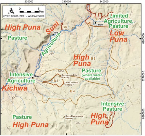
A brief review the geography of Upper Colca study area better contextualizes the ancient lifeways and relationships that are the subject of this dissertation. The 2003 research project was organized into three distinct blocks of contiguous survey (1, 2, 3) with other adjacent areas numbered 4, 5, and 6. The three major survey blocks correspond with ecological zones in the Upper Colca area and the overall ecological variability in the project area will be reviewed here by a discussion of each block.
Ecological complementarity between highland herders and valley agriculturalists is a widespread feature of Andean economy. Research into the productive potential of "pure" pastoralism in the Andes has shown that the caloric return and efficiency is insufficient to sustain communities without inputs from non-pastoral communities (Thomas 1973;Webster 1973). The Upper Colca study area lies immediately above the altitude of intensive valley agriculture that begins at the village of Tuti (3840 masl), corresponding with the upper portion of the suniand with the punaecological zones, and reflecting the local precipitation and temperature gradient (ONERN 1973: 39;Pulgar Vidal 1946). The town of Tuti is at approximately the altitude of Lake Titicaca, and in some ways the land use practices observable upstream of Tuti in the Callalli area are comparable to those in the Lake Titicaca Basin, although this western slope location does not have the moderating effect of the large lake body itself.
|
Local elevation |
Zone |
Description |
Upper Colca Survey Blocks |
|
4000 - 5000 |
Puna |
Rich pasture lands and rugged volcanic terrain in the Chivay obsidian source area, the San Bartolomé puna near Chalhuanca, and below to the town of Pulpera. |
1, 2, 4, 5 |
|
3600 - 4000 |
Suni |
High elevation agricultural lands, lower quality pasture, upper river valley from Chivay to Sibayo / Callalli. |
3, 6 |
|
3300 - 3600 |
Kichwa |
Lower portion of the main Colca valley. |
None |
Table 4-1. Andean ecological zones with approximate local elevation values for each zone.
Annual rainfall ranges from 550 and 750 mm, depending on elevation, and the average annual temperature is 1° C in the puna (ONERN 1973). In this area, precipitation is higher with altitude, but temperature, especially night time temperature, drops with altitude. The result is a balance between the potential for dryland agriculture, altitude, and climate that has periodically allowed farming in the Upper Callalli area in prehispanic and Hispanic times.
Figure 4-2. Survey blocks in the Upper Colca study area are shown with modern production zones described in Table 4-1. These zones reflect changes in altitude and rainfall as the Colca river, descending westward, is surrounded by puna pasture lands.
A relationship of mutual benefit exists between residents and resources of the higher altitude ecological zones and the vegetatively-productive main Colca valley. A principal assumption of this research is that the procurement of resources like obsidian have long been structured by the human use of complementary ecological zones. Some form of regular articulation between the highlands and the valley therefore probably existed through much of prehistory without special recourse for obsidian provisioning. This interaction may have taken the form of regular visits to the Chivay obsidian source area by valley agriculturalists, who may have been hunting or herding in the adjacent highlands, or by way of visits by highland pastoralists traveling from the puna regions in order to visit the Colca valley to barter for agricultural goods.

