6.3.2. Block 2 - Archaic San Bartolomé
The Block 2 survey area parallels the edge of the Huarancante lava flow where geological features include the contact between the toe of a Pliocene lava flow and the open pampa. The pampa consists of ignimbrites weathering into a sandy soil and surface water in this area creates grassland with bofedales. Considering the study area on the whole, the greatest intensity of occupation during the pre-pastoralist Archaic appears to have taken place at San Bartolomé (Block 2). Sites in the area were surface collected in previous years by students from field classes at the Catholic University of Santa Maria in Arequipa (José-Antonio Chávez Chávez, Sept 2002, pers. comm.), but nevertheless a high density of projectile points was found in this area.
The evidence for long duration and diversity of activities comes primarily from the spatial distributions of projectile points and their material types. The San Bartolomé area was also an important zone during the subsequent pastoralist periods, due in large part to the rich bofedales mentioned above, that make differentiating pastoralist from Archaic Foragers (Early, Middle, and Late Archaic) occupations difficult. For foragers during the Archaic Period the area contains a rich mixture of reliable hunting opportunities and access to lower elevation vegetative resources in the Colca valley, two days travel away.
Projectile point distributions
Block 2 contained an abundance of projectile points diagnostic to the Archaic Foragers period. The wide variety of point types probably reflects the mobile strategies of Archaic foragers and the variable geology of the larger region.
|
Period |
Point Type |
Obsidian |
Volcanics |
Chalcedony |
Chert |
Quartzite |
|
Archaic |
3d |
489 |
449, 1019 |
394 |
||
|
E Arch |
1a |
355, 379, 380, 941, 1015, 1037, 1044.2 |
384 |
384 |
||
|
1b |
398, 411, 493, 522, 945, 956.3, 1026.3 |
444,514, 956.2 |
469, 1034 |
|||
|
E-M Arch |
2a |
512, 949 |
||||
|
L Arch |
3f |
490 |
390, 480 |
|||
|
4d |
960, 963, 964, 1017, 1018, 1024.4, 1024.5, 1048, 1067 |
|||||
|
Late Arch - T Arch |
4f |
407, 450, 463, 818, 943, 954, 1031 |
364, 1057 |
486 |
||
|
M Arch |
2c |
517, 873, 953, 1016, 1023, 1035, 1036, 1044, 1062 |
822, 1021 |
|||
|
3b |
386, 820, 944 |
958, 1051 |
509, 942 |
951 |
||
|
3e |
519 |
395 |
||||
|
MH |
4e |
472 |
Table 6-25. Diagnostic Projectile points Series 1-4 from Block 2 identifed by ArchID number.
Obsidian projectile points are extremely well represented in this area, but fine-grained volcanic material, primarily andesite, is also relatively abundant among the projectile point types except the Series 5 points. Chert and chalcedony points were present in Block 2, as well as chert knapping debris in low densities throughout the area, suggesting that chert nodules are available in relative proximity as well.
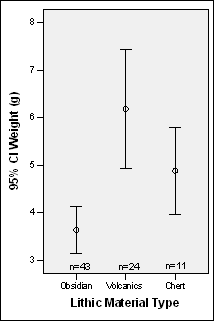
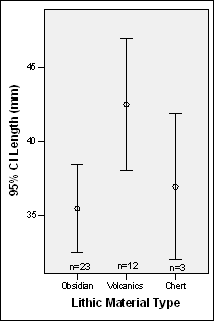
Figure 6-16. Projectile Point weights and lengths (when complete) by material type for Block 2. Series 5 points are excluded, chalcedony is included with chert, and quartzite is described separately.
Obsidian is well represented by count, but obsidian is typically smaller regardless of material type, even if the small, triangular Series 5 point types are excluded. An analysis of variance of material type showed that these differences between mean weights was extremely significant (F = 11.511, p> 05). Remarkably, even in this region, which is a day's travel from the Chivay source, obsidian appears to be used in the smaller size range of projectile points of the larger types.
Comparing the counts for weights and lengths in Figure 6-16 reveals that approximately one-half of the projectile points made from both obsidian and fine-grained volcanic materials are longitudinally snapped (and therefore no length measurement was taken). Thus, this difference in weights between obsidian and volcanics does not reflect differential breakage by obsidian points as it appears that the mean lengths of non-broken obsidian points are also roughly 8cm shorter than the mean lengths of fine-grained volcanic points. Other possible explanations for the smaller obsidian projectile points include the in-haft resharpening and other forms of recycling that would result in smaller sized obsidian points in the styles of larger types. The was evidence of resharpening noted on some projectile points, but a restudy would be required to examine resharpening evidence consistently in the collection.
Block 2 Archaic Foragers Settlement Pattern
Archaic Forager sites in the Block 2 portion of the survey fall into two major categories as indicated by the surface materials. One category of site consists of large sites that are sheltered in at least one sector of the site, and the other type of site appear as more diffuse scatters along the edge of the grassy plain that are largely intermingled with the pastoralist settlement pattern. These two kinds of sites will be discussed below, along with the characteristics of the artifacts found in each type of site.
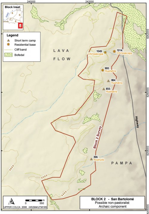
Figure 6-17. Archaic Forager sites in Block 2: Major sites described in the text.
Site Type: Residential Base
Archaic Forager period sites take two principal forms in this survey block. Residential bases, with what appears to be a great deal of redundancy of occupation, were encountered in a few locations with distinctive attributes (like shelter from wind). Projectile points styles diagnostic to Archaic Foragers time periods are encountered in a variety of contexts that include some areas near bofedales that were later intensely utilized by pastoralists, and some areas that show more spatially distributed occupational histories.
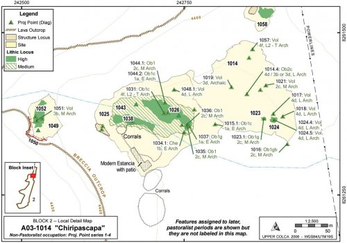
A03-1014 "Chiripascapa" [A03-1014 - A03-1057]
Chiripascapa was recorded as three sites due to variability in the artifact distributions and the differences in topography. Due to downslope movement in the steep talus zone in one portion of the site, and deflation in the lower site complex, the Archaic Foragers component of this site complex will be described as one group.
|
ArchID |
SiteID |
FileType |
Description |
Area (m2) |
|
1014 |
1014 |
Site_a |
"Chiripascapa" |
24,550,334 |
|
1023 |
1014 |
Lithic_a |
Medium Dens, 100 Obs |
38,785 |
|
1024 |
1014 |
Lithic_a |
Medium Dens, 89 Obs |
124,943 |
|
1025 |
1025 |
Site_a |
"Chiripascapa2" |
27,927,630 |
|
1026 |
1025 |
Lithic_a |
High Dens, 100 Obs |
2,470,331 |
|
1038 |
1025 |
Lithic_a |
High Dens, 30 Obs |
1,086,213 |
|
1041 |
1025 |
Ceram_a |
Painted LIP |
186 |
|
1043 |
1025 |
Lithic_a |
Medium Dens, 100 Obs |
9,484,728 |
|
1045 |
1025 |
Struct_a |
Wall Bases Only, Cave |
128 |
|
1052 |
1025 |
Lithic_a |
Medium Dens, 100 Obs |
888,906 |
|
1049 |
1049 |
Site_a |
"Chiripascapa3", Rock shelter |
3,657,074 |
Table 6-26. Loci in Chiripascapa
Description
The upper part of Chiripascapa consists of one medium sized rock shelter and three small rock shelters at the base of an east-north-east facing portion of the Huarancante volcanic breccia lava flow escarpment. Below the rock shelters a sloping talus field (a 25° slope), littered with lithics as well as ceramics, leads to a small intermittent stream 20 vertical meters below the rock shelter. On the banks of this stream is a scatter of lithics and ceramics from a variety of time periods that extend downstream for approximately 300 m. The south bank of the stream has a modern estancia (Pausa) and a large corral below the associated buildings, seriously disturbing any artifact scatters on the south bank. The north bank of the stream is also disturbed. Large scars from bulldozers scraped off the topsoil in certain areas. The resident at the Pausa estancia explained that during the 1970s highway improvement for the Majes Project the road crews caused these impacts as they were looking for gravel sources in that area. Just north of this site complex is a large, active gravel pit.
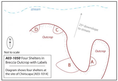
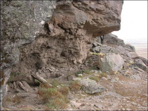
Figure 6-18. A03-1050 consists of four rock shelters: A, B, C, and D.
Figure 6-19. Chiripascapa [A03-1014], Archaic Foragers occupation.
A03-1050 - Four rock shelters of Chiripascapa
These rock shelters appear to be well situated with respect to the surrounding geography. The shelters face east-north-east and so despite being in a dark and slightly damp corner of the lava toe they catch the morning and midday sun. It is worth noting that the estanciadepicted in the center of the map appears to be deliberately built with the same aspect. The rock shelter is relatively well-hidden because it lies about 50m up a side quebrada and therefore goes unnoticed unless you climb the quebrada. Despite the concealed position, this location actually offers a partial view of the most important resource in the zone: the bofedal one km to the north-east. It would also be possible to monitor travel through the Ventanas del Colca access to the upper Colca from this hidden location. The stream below the shelters was dry at the end of the dry season, but probably flows most of the year.
Due to low GPS reception in the rock shelter area the four rock shelters were mapped as a single Struct-L line "A03-1050" and differentiated as A, B, C, and D. Only one shelter, the one designated as A03-1050B, had the characteristics of a residential shelter. The dimensions of this shelter are as follows. Height:2m, Depth:6.5m, Width:7m. Due to the overhanging roof formed from the lava flow, a considerable area is dry outside of the walls of the cave. This area shows signs of having been improved as a patio and the "patio" area extends the depth of the dry zone by another 12.5m. The rock shelter 1050A was large but wet, and 1050C and 1050D were very small but dry.
Below the rock shelters a talus slope extends approximately 20 vertical meters to the stream. A variety of lithics and ceramics were identified on this slope, though only one projectile point was diagnostic to a period that falls in the Archaic Foragers timespan. This point [A03-1051] was a Middle Archaic andesite point and it had a transverse snap and missing its haft element, suggesting that it was broken in use.
Features and Artifacts
The stream enters the open, sandy soils of the pampa and on either bank of the stream, though primarily on the north bank, projectile points from throughout the Archaic sequence were found. Preservation is relatively poor on this section of the pampa. In addition to the bulldozer impacts mentioned above, the soils appear deflated and this partly explains the high density of projectile points, from virtually every time period, found in this area. It seems possible that the entire site scatter was formerly more aggregated on the western part of this map, and with riverine transport the artifacts have been scattered over the pampa.
|
ArchID |
Artif. # |
Material |
Form |
Type |
Temporal |
|
1015 |
1 |
Obsidian |
Proj Point Broken |
1a |
Early Archaic |
|
1016 |
1 |
Obsidian |
Proj Point |
2c |
Middle Archaic |
|
1017 |
1 |
Volcanics |
Proj Point Broken |
4d |
Late Archaic |
|
1018 |
1 |
Volcanics |
Proj Point |
4d |
Late Archaic |
|
1019 |
1 |
Volcanics |
Proj Point |
3d |
Archaic |
|
1021 |
1 |
Volcanics |
Proj Point Broken |
2c |
Middle Archaic |
|
1023 |
1 |
Obsidian |
Proj Point |
2c |
Middle Archaic |
|
1024 |
4 |
Volcanics |
Proj Point |
4d |
Late Archaic |
|
1024 |
5 |
Volcanics |
Proj Point Broken |
4d |
Late Archaic |
|
1026 |
3 |
Obsidian |
Proj Point |
1b |
Early Archaic |
|
1031 |
1 |
Obsidian |
Proj Point |
4f |
Late-Term. Archaic |
|
1034 |
1 |
Chert |
Proj Point |
1b |
Early Archaic |
|
1035 |
1 |
Obsidian |
Preform |
2c |
Middle Archaic |
|
1036 |
1 |
Obsidian |
Preform |
2c |
Middle Archaic |
|
1037 |
1 |
Obsidian |
Proj Point |
1a |
Early Archaic |
|
1044 |
1 |
Obsidian |
Preform |
2c |
Middle Archaic |
|
1044 |
2 |
Obsidian |
Proj Point |
1a |
Early Archaic |
|
1048 |
1 |
Volcanics |
Proj Point |
4d |
Late Archaic |
|
1051 |
1 |
Volcanics |
Proj Point Broken |
3b |
Middle Archaic |
|
1057 |
1 |
Volcanics |
Proj Point Broken |
4f |
Late-Term. Archaic |
Table 6-27. Diagnostic Series 1 through 4 projectile points from Chiripascapa [A03-1014].
The temporal distribution of projectile points from Chiripascapa shows that virtually every time period is well represented. One distinction worth noting is that obsidian is used almost exclusively in the later time period, while about 50% of the projectile points (by count) are made from obsidian in the early time periods presented by Series 1 - 4 points.
|
Projectile Points |
Obsidian |
Volcanics |
Chalcedony |
Chert |
|
Series 1 - 4 |
10 (48%) |
9 (43%) |
1 (5%) |
1 (5%) |
|
Series 5 |
24 (96%) |
1 (4%) |
0 |
0 |
|
Total |
34 |
10 |
1 |
1 |
Table 6-28. Representative proportions of material types by projectile point styles.
The medium and high density lithic loci along the creek banks are difficult to temporally isolate because there are later period diagnostics, including twenty-six Series 5 projectile points and ceramics dating from the Middle Horizon, LIP, and Inka periods found in the A03-1038 lithic locus. Most of the flakes observed at this site were obsidian and chert. A small concentration of andesite flakes on the south bank of the stream in locus A03-1038 was observed, despite the fact that all andesite projectile points came from the north bank of the stream.
|
Material Type |
Obsidian |
Volcanics |
Chalcedony |
Chert |
Quartzite |
|
No. |
88 (62%) |
32 (23%) |
5 (4%) |
15 (11%) |
1 (0.7%) |
|
Mean Wt (g) |
5.05 |
18.28 |
16.7 |
10.91 |
11.5 |
|
% by Sum Wt |
34.5% |
45.6% |
6.7% |
12.3% |
0.9% |
Table 6-29. All lithic artifacts from Chiripascapa.
The surface materials included bifaces, cores, and flakes of all local material types except quartzite, which was rare at the site. Based on the mean flake size and the percentage of the total contribution by weight, fine-grained volcanics appear the most local to the area. Isolating any one of the lithic concentrations to a particular time period is difficult, but when viewed collectively including the point scatters in A03-1014 and A03-1025, and the rock shelters in A03-1049, the site complex is one of the oldest residential areas in the larger study area. The rock shelter A03-1050B and the built up patio has a high probability of containing a stratified intact deposit that extends into the earlier parts of the Archaic.
A03-900 "Huañatira"
Huañatira is a horseshoe-shaped valley with escarpments of lava flows of volcanic breccia on three sides and a small rise in the center where a single toe of lava extends down lower towards the pampa. The result is a sheltered, circular valley with a sloping ramp that climbs towards the top of the lava flow to the east of the valley. The Huañatira valley provides a moderately sheltered area with good views of the surrounding pampa, and it is defensive because it provides means of escaping to the higher lava flow terrain without being observed by pedestrians approaching from the pampa.
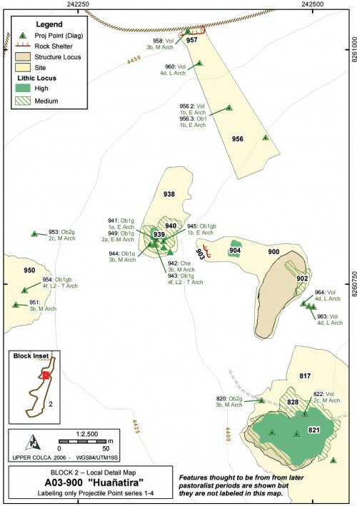
Figure6-20. Huañatira [A03-900] and vicinity, Archaic Foragers occupation.
Description
The area has evidence of occupation from virtually every time period from the Early Archaic to the modern period. A maintained estancia is found just to the west of the study area shown in Figure 6-20, and a small driveway is shown on the map accessing the area from the east. A worn trail departs the estancia to the west; a travel route that probably dates to the pastoral period if not earlier. Projectile points were found scattered around the valley that date to all periods, however most of the large scale archaeological features in this area appear to be from the pastoralist period. The circular or oval features shown as structural loci (not labeled on Figure 6-20) are most likely of pastoralist origin. A rock shelter offering partial protection was found in the center of site 900 overlooking the pampa [A03-903]. This immediate valley area belongs to a very small local watershed, and during the dry season there was no apparent surface water. This small watershed prevented a great deal of surface runoff; a factor has probably helped to maintain artifact positions in their original contexts in this local valley more than at other sites from the survey.
|
ArchID |
File Type |
ArchID (cont.) |
File Type |
|
|
817 |
site_a |
940 |
lithic_a |
|
|
820 |
site_p |
941 |
lithic_p |
|
|
821 |
lithic_a |
942 |
lithic_p |
|
|
822 |
site_p |
943 |
lithic_p |
|
|
823 |
site_p |
944 |
lithic_p |
|
|
824 |
site_p |
945 |
lithic_p |
|
|
825 |
site_p |
946 |
lithic_p |
|
|
826 |
site_p |
947 |
lithic_p |
|
|
827 |
site_p |
948 |
site_p |
|
|
828 |
lithic_a |
949 |
lithic_p |
|
|
830 |
struct_p |
951 |
lithic_p |
|
|
831 |
site_p |
953 |
lithic_p |
|
|
900 |
site_a |
954 |
lithic_p |
|
|
902 |
lithic_a |
956 |
site_a |
|
|
903 |
struct_l |
957 |
struct_l |
|
|
904 |
lithic_a |
958 |
struct_a |
|
|
905 |
lithic_p |
960 |
lithic_p |
|
|
906 |
site_p |
961 |
lithic_p |
|
|
907 |
site_p |
962 |
lithic_p |
|
|
938 |
site_a |
963 |
lithic_p |
|
|
939 |
lithic_a |
964 |
lithic_p |
Table 6-30. Non-consecutive ArchID numbers at Huañatira [A03-900], an Archaic Foragers site.
A03-957 - Rock shelter
This is a relatively large rock shelter overlooking the pampa and the valley of Huañatira. Contrary to most residential rock shelters in the region, this shelter faces south-east and it is therefore not exposed to the warming sun and was probably a shelter that was cool in temperature nearly all year reducing its potential as a residential structure in the altiplano. The shelter offers a relatively large amount of residential space inside the dripline; the rock shelter is 7m deep from the dripline, 12m wide, and over 3m high. Virtually all of the interior space of the shelter is clear of rubble and useable for residential activities. Four projectile points from the Early, Middle, and Late Archaic Periods were found associated with this shelter. A recessed tomb dominates this shelter today, but given the size of the feature and the pattern of cave burial during the Late Intermediate Period, the mortuary feature in this shelter is interpreted as a LIP cist tomb. These features are described in the Late Prehispanic - Block 2 discussion (Figure 6-76), close to the end of this chapter.
Figure 6-21. Rock shelter of Huañatira with circular mortuary feature visible inside. One meter scale showing on tape resting on rock along dripline (see also Figure 6-76).
Features and Artifacts
Some cases of disturbed artifact provenience are obvious, such as the three projectile points in a wash at the base of the valley shown as the three points on the eastern edge of Figure 6-20. Also the points below the Huañatira rock shelter on the north end ofthis site were found in the colluvial zone below the shelter and were apparently displaced.
|
ArchID |
Index# |
Material |
Form |
Type |
Temporal |
|
820 |
1 |
Obsidian |
Proj Point |
3b |
Middle Archaic |
|
822 |
1 |
Volcanics |
Proj Point |
2c |
Middle Archaic |
|
941 |
1 |
Obsidian |
Proj Point |
1a |
Early Archaic |
|
942 |
1 |
Chert |
Proj Point Broken |
3b |
Middle Archaic |
|
943 |
1 |
Obsidian |
Proj Point |
4f |
Late - Terminal Archaic |
|
944 |
1 |
Obsidian |
Proj Point |
3b |
Middle Archaic |
|
945 |
1 |
Obsidian |
Proj Point |
1b |
Early Archaic |
|
949 |
1 |
Obsidian |
Proj Point |
2a |
Early-Middle Archaic |
|
951 |
1 |
Quartzite |
Proj Point |
3b |
Middle Archaic |
|
953 |
1 |
Obsidian |
Proj Point |
2c |
Middle Archaic |
|
954 |
1 |
Obsidian |
Proj Point |
4f |
Late - Terminal Archaic |
|
956 |
2 |
Volcanics |
Proj Point Broken |
1b |
Early Archaic |
|
956 |
3 |
Obsidian |
Proj Point Broken |
1b |
Early Archaic |
|
958 |
1 |
Volcanics |
Proj Point Broken |
3b |
Middle Archaic |
|
960 |
1 |
Volcanics |
Proj Point |
4d |
Late Archaic |
|
963 |
1 |
Volcanics |
Proj Point Broken |
4d |
Late Archaic |
|
964 |
1 |
Volcanics |
Proj Point |
4d |
Late Archaic |
Table 6-31. Diagnostic Series 1 through 4 projectile points from Huañatira [A03-900].
Artifact proportions are consistent with other Archaic Foragers sites in the area, with approximately 50 of the projectile points and 65 of all collected lithic artifacts being of obsidian. A number of bifaces and flakes were found at this site, primarily of fine-grained volcanic stone and obsidian, and one obsidian core.
|
Material Type |
Obsidian |
Volcanics |
Chalcedony |
Chert |
Quartzite |
|
No. |
50 (64%) |
14 (18%) |
3 (4%) |
9 (12%) |
2 (3%) |
|
Mean Wt (g) |
4.97 |
99.8 |
31.4 |
49.5 |
111.1 |
|
% by Sum Wt |
10.4% |
57.8% |
4.2% |
17.6% |
9.9% |
Table 6-32. All lithic artifacts from Huañatira.
As with other residential areas in Block 2, it is difficult to differentiate the Archaic Foragers component in this area of heavy reoccupation. The area contains a large rock shelter and it provides a measure of shelter on the border of the pampa, as do the other shelters in the area. Several Late Archaic projectile points are dark fine-grained volcanic rock, akin to the Late Archaic (4d) points found at that Chiripascapa [a03-1014] a short distance to the north.
Site Type: Sites with majority non-obsidian lithics
A substantial Archaic presence in Block 2 takes the form of diffused, low density scatters with associated diagnostic projectile points along the edge of the pampa and frequently close to water sources. These finds are very difficult to differentiate from the pastoralist site occupation pattern and therefore these features will be described as a group, followed by generalizations about the characteristics of the environmental and cultural features of sites of this type in Block 2.
While the Archaic Foragers use of space largely overlaps with pastoralist occupation areas in Block 2, the use of lithics appears to differentiate the two. As was discussed in Chapter 3 (Section 3.4.4), the use of obsidian for projectile points expands dramatically at the end of the Archaic Foragers period both near the Chivay source and in the consumption zone.
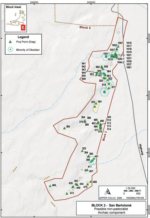
Figure 6-22. Block 2 Archaic Foragers component from lithic evidence.
Method
The criteria used here for sites isolating through the dominance of particular material types are as follows for both lab analysis Lithics_I and Lithics_II. First, the lab results by SiteID (or isolated ArchID), showing count and percent, were shown in a table against material type in Arcmap. This table was joined to the All_ArchID_Centroids point geometry [link to Processing in Ch 5] so that lab results for lithic material types were aggregated by site or isolate. These features were then filtered by constructing a query where the artifact count for a geographical feature had to be greater than 5 so that relative percentages were meaningful. Finally, the index symbolized inFigure 6-22 is the Lithics_I lab results (the most comprehensive table) where Percentage of Non-obsidian lithic artifacts is greater than or equal to 50%.
Results
The use of non-obsidian materials such as chert, chalcedony, and especially fine-grained volcanic materials, dropped precipitously during the Terminal Archaic at sites in Block 2. While all lithic material types persist in use during the pastoral period, the herd management tasks of butchery and shearing appear to have been largely conducted using obsidian. Reviewing the percentages of sites with strong evidence of a pastoralist occupation (only Series 5 projectile points, a corral, water, and grazing opportunies) these sites commonly have between 20% - 40% non-obsidian flaked stone. Thus, the distinction between pastoralist and forager components based on material type is not firm, but the distributional pattern is reinforced by non-series 5 projectile point distributions, and this evidence is shown together in Figure 6-22.
Six sites have been identified with a relatively robust Archaic Foragers component in Block 2 and the environmental characteristics of these six sites will be compared with all locational characteristics of B2 sites in order to look for patterning among the environmental criteria of Archaic Foragers sites. These six sites include the following A03- 396, 884, 894, 900, 1014, 1049 and while diagnostics from the Archaic Foragers period were widely encountered throughout the region, these sites are selected as representantive for the larger Archaic Foragers time period and life way based on inference. Clearly the boundaries of the "site" are probably not coterminous with the Archaic Foragers component of these sites, nevertheless these measures serve as a general indicator of changes in the environment context of settlement through time.
|
Selectedm |
Selecteds |
All B2 Sitesm |
All B2 Sitess |
All B2 Sitesm - Selectm |
|
|
Altitude (masl) |
4382.6 |
12.69 |
4393.2 |
25.7 |
-10.6 |
|
Slope (degrees) |
7.86 |
8 |
8.33 |
6.34 |
-0.47 |
|
Aspect (degrees) |
146.5 |
96.4 |
138.4 |
58.23 |
8.1 |
|
Visibility/Exposure |
33.6 |
13.1 |
40.1 |
25.53 |
-6.5 |
|
Dist. to Bofedal (m) |
497.3 |
212.2 |
307.5 |
261.5 |
189.8 |
Table 6-33.Environmental characteristics of selected Archaic Foragers sites in Block 2.
The high standard deviation values in the Table 6-33 "Selected sites" underscores the variability and inconsistency in these estimates. This comparison shows that the Archaic Foragers sites tend to be more sheltered/lower visibility than the pastoralist sites. As was previously noted, the Archaic Foragers sites are often adjacent to overlooks but the sites often do not occupy the high exposure area specifically. Archaic Foragers sites are considerably further than average from bofedales. This strong tendency in the data is probably accentuated by the intensification and maintenance of pastoral resources that has occurred in recent years. That is to say, as pastoralism is today the principal economy activity in the area, bofedales and attendant pastoral facilities have been well-maintained in the recent past, which is the criteria from which bofedales were selected from the ASTER satellite imagery for this measure. A further issue with respect to distance to water is the fact that many of the potential forager sites are adjacent to small streams that were probably seasonal and appear as dry in the modern dry-season ASTER imagery.
Discussion
Block 2 survey area represents a transition from the rugged lava flow topography on the west side of the block to the open pampa on the east side of the block. In addition, residents in the Block 2 area are able to exploit the higher density off resources in the puna while maintaining access and, perhaps, social relationships with residents in the adjacent lower altitude portions of the Colca valley.
A number of obsidian projectile points in this area were produced in the same general forms as chert points and, particularly, as fine-grained volcanic points. These forms are most akin to those documented at Sumbay, 30 km to the south. Given the greater local variability in point forms during the Late Archaic (Klink and Aldenderfer 2005: 53), the data from the Block 2 area provides an opportunity to study the local projectile point styles, best known from the Sumbay style points, in conjunction with the regional interaction documented through obsidian distribution data.
