5.4. Survey Strategy
5.4.1. Goals of Survey and Testing
The goals of the Upper Colca Archaeological Survey were to document the prehispanic use of the Chivay obsidian source and to record changes in obsidian processing evident at the source. Quarry research presents special challenges to archaeologists because prehistoric patterns are obscured by the sheer quantity of non-diagnostic materials from early reduction stages, and the compounded reuse of space over time (Ericson 1984;Torrence 1986). Working at the Chivay obsidian source involved additional challenges in its remote location at high altitude where roads and electrical sources were unavailable. The research design therefore had to maximize the time spent camping at the high altitude source using field methods that could be used effectively to detect variability in obsidian production at the source.
Very few archaeologists had visited the source area prior to this work, and therefore the research team had to accomplish basic documentation of the source area. However, detecting change in obsidian production required a relatively in-depth investigation, such as analyzing lithic production loci and excavating test units to acquire temporal control. Preliminary visits in 2001 and 2002 indicated that the rugged, high altitude terrain around the Chivay source precluded a systematic and extensive survey of contiguous lands near the source. While total coverage surveys are preferable in theory, it simply was not worthwhile to survey many square kilometers of jumbled rhyolite boulders and skree fields, terrain that were barely passable on foot, when the vast majority of all the locations for sizable sites could be targeted by the general criteria evident on maps and imagery. Furthermore, a comprehensive study of activities related to the source area demanded that time was budgeted for an investigation of the highly productive lands approximately one day's travel away from the obsidian source, in order to place obsidian procurement in the context of the local economy. A research strategy that approached the entire region in terms of survey and testing in three major contiguous blocks was deemed the most effective approach to documenting the source region.
5.4.2. Surveys types: Prospection, Statistical, and Spatial Structure
The principal goal of the survey work was to document archaeological distributions in source area and adjacent terrain. Banning (2002) describes the goals of archaeological survey in terms of three principal types of survey that emphasize different research goals.
|
Type |
Prospection / Purposive |
Statistical |
Spatial Structure |
|
Application |
For findingarchaeological sites. |
For estimating population parameters, evaluating probabilistic hypotheses and constructing locational models. |
For detecting spatial patterns such as settlement lattices, travel routes. Also good for documenting continuous phenomena. |
|
Implementation |
Prioritize the locating of sites by incorporating background information, predictive models, and remote sensing. |
Sampling strategies for documenting artifact density, diversity, and site types within stratified samples or numerical samples. |
"Total coverage" or nonsite survey to identify spatial interrelationships that might be missed by sampling approaches. |
Table 5-3. Types of archaeological survey described by Banning(2002: 27-38).
Banning makes the point that while sampling is a common approach to archaeological survey, sampling is actually a poor method for prospecting for sites or for characterizing settlement lattices because major clues can fall outside of the sampling window. Each method has specific strengths and weaknesses, and often archaeological surveys are a mixture of several types.
5.4.3. Surveyor interval and sampling
Following Banning's (2002) terms, the Upper Colca survey work was a combination of all three survey types. The survey was prospective because it attempted to document a little known region and find the majority of the large sites associated with the obsidian source, but it was also statistical because survey zones were deliberately stratified so as to permit predictive statements about the use of space throughout the study region. Finally, the Upper Colca research also involved survey for spatial structure because it consisted of three large blocks within which the land was thoroughly surveyed so as to document intersite relationships and travel routes.
Many contemporary archaeological surveys will claim to have conducted "100% survey" of large regions, but then they will have had a survey interval of 30m or more between surveyors. Surveys focused on documenting complex societies with standing architecture are particularly likely to refer to their widely-spaced surveys as "100% surveys". A wide surveyor interval is actually a non-explicit kind of sampling that de-prioritizes smaller sites and those lacking standing architecture, resulting in an often unstated bias in the results. Subsequently, the region is considered "surveyed" though many smaller sites falling between transects were surely missed. While smaller sites are found in these widely spaced surveys, it is only if the site happens to fall across one of the surveyor lines. More realistically, such a survey method is somewhat successful because the surveyors cover a lot of ground but then they will veer off their route to visit high likelihood locations for sites such as rock shelters and lake shores; a technique belonging to the realm of prospection survey.
5.4.4. Survey design
The Upper Colca Project survey goals emphasized investigating the Chivay source area, the geological contexts for obsidian formation, and the principal areas of human settlement within one day's walk from the source. In the implementation of the survey, high-likelihood areas in the obsidian source zone were evaluated using a prospection survey. This included a careful survey of the entire Maymeja area itself and large portions of the southern rim using a surveyor interval of 15m.
|
Source |
Institution |
Scale / Res. |
Comments / Application |
|
ASTER imagery |
NASA, JPL(Abrams, et al. 2002) |
15m |
Visual and NDVI analysis |
|
ASTER DEM |
NASA, JPL(Abrams, et al. 2002) |
30m |
Representation, slope calculation |
|
SRTM DEM |
NASA, USGS, CGIAR (Jarvis, et al. 2006) |
90m |
Regional relief mapping |
|
Aerial photos |
Servicio Aerofotográfica Nacional, Perú |
1:60,000 |
Historic aerial photos. |
|
Topographic maps |
Instituto Geográfica Nacional, Perú |
1:100,000 |
Features, toponyms (PSAD56), scanned |
|
Geology maps |
INGEMMET, Perú |
1:100,000 |
Geology (PSAD56), scanned |
|
VMAP1 |
NIMA (1995) |
1:250,000 |
Regional map |
|
VMAP0 |
NIMA (1995) |
1:1 million |
Continental map |
Table 5-4. Digital data sources used in developing the survey strategy.
Selection of survey regions involved the use of a number of spatial data sources (Table 5-4), as well as interviews with local residents, personal visits, and consultation of previously published reports. Preliminary field visits with a Trimble Geoexplorer GPS in 2001 and 2002 involved collecting ground control points and GPS lines on major roads and other features. After post-processing using the AREQ base station (International GPS Service), these data permitted the georeferencing of aerial photos and scanned maps directly to the GPS acquired data.
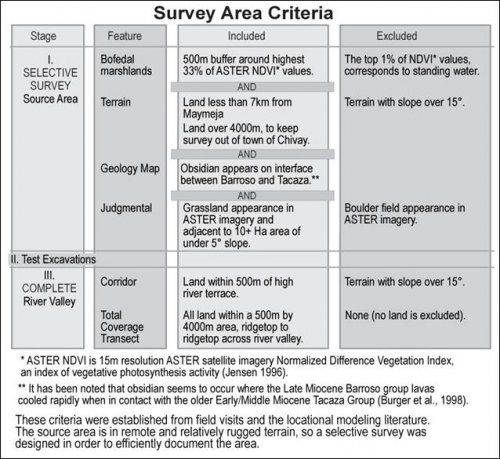
Figure 5-1. Criteria in designing regional survey from three stage research proposal including obsidian source survey, testing program, and concluding with the river valley survey.
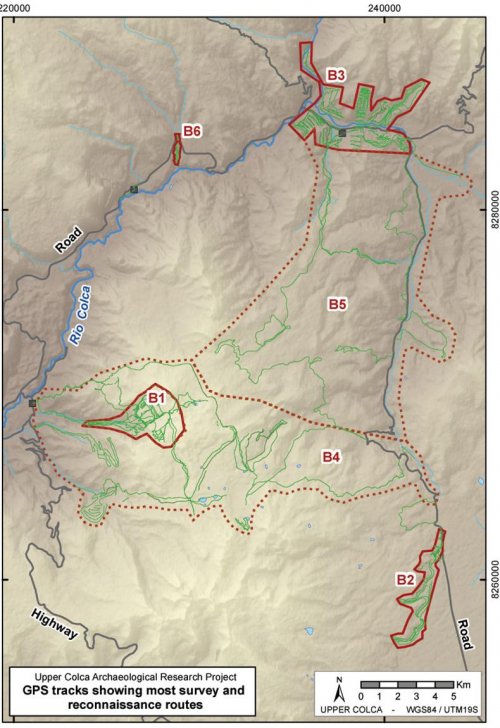
Survey in the area of the obsidian source, outside of the Maymeja depression itself, was selective as it focused on high likelihood areas. Survey coverage in the Blocks 2 and 3 zones was contiguous with a 15m surveyor interval although here the survey region was delimited by other criteria. First, in the Block 2 (San Bartolomé area) a particular strip of land was targeted that paralleled the terminus of a Barroso lava flow. The survey block was surveyed 100% at 15m intervals along this densely occupied region. In Block 3, a maximum steepness and distance to river criteria was used to concentrate survey efforts to the river corridor region. Thus, in Block 3, all lands were surveyed within 500m of the high river terrace above the principal drainage (Colca, Llapa, and Pulpera drainages), and terrain over 15° slope (33% slope) were not surveyed. This maximum steepness limitation excluded many eroded regions where preservation is poor, but it also excluded a number of areas that were perhaps occupied. In order to evaluate the survey criteria in Block 3, a swath of land 1 km wide by 3 km long was surveyed at truly 100% coverage at 15m interval, and these areas could then evaluated to gauge the effects of the survey criteria used elsewhere in Block 3 that excluded the high slope and non-riverside areas. This 100% survey test swath will be described in more detail below.
Figure 5-2. GPS tracks from edges of most survey routes showing emphasis on Blocks 1, 2, 3 and 6.
With GPS units the survey coverage and spatial sampling is made relatively explicit, permitting future researchers in the region to focus on areas that were under-investigated in the 2001, 2002 and 2003 survey efforts. With GPS track loggers becoming easily available, explicit coverage reporting will likely be more widely adopted in the future.
5.4.5. Testing the effectiveness of the B3 survey strategy
While survey criteria for coverage in Block 3 were relatively restrictive, a swath in the vicinity of Callalli with a diversity of topographic and ecological conditions was selected for conducting a "100% survey". The goal of covering ground at a 100% was to evaluate the effectiveness of the survey strategy that was being applied throughout the rest of Block 3. The survey coverage in Block 3 included only areas within 500m of the highest river terrace, and slopes under 15° (33.3%) incline.
The 100% survey revealed seven small sites, some lithic isolates, a lone broken vessel and a wall on a hilltop location that was undiagnostic but is probably a Late Intermediate Period pukara construction. The area of the 100% survey swath is 0.5 km wide by 3.5 km long (area = 1.7 km2) and if onlythe area outside of the regular survey model is included, the area is 1.1 km2. The sites located in the areas outside of the survey model fall into two major groups: pukaras on hilltops and small, eroding lithic scatters with no reliable temporal assignment found on steep open slopes. Other regional evidence points to a pattern of intensified pastoral production during the LIP and Late Horizon, and these dispersed sites may result from herders working while they monitor their flock during the wet season when the hillslopes of Callalli contain rich graze.
|
ArchID |
Slope° |
Altitude |
Feature type |
Notes |
|
587 |
29.4 |
4185 |
lithic_p |
|
|
588 |
15.1 |
4128 |
site_a |
|
|
589 |
20.3 |
4156 |
site_a |
Visib is +33 |
|
590 |
8.9 |
4100 |
site_a |
|
|
591 |
16.0 |
4073 |
site_a |
|
|
592 |
18.2 |
4077 |
site_a |
|
|
593 |
21.0 |
4020 |
lithic_p |
|
|
594 |
22.8 |
3967 |
site_a |
|
|
605 |
11.7 |
4087 |
ceram_p |
|
|
607 |
13 |
4164 |
site_a |
Pukara. Visib is +3.12 |
|
608 |
15.3 |
4161 |
ceram_p |
|
|
609 |
19.6 |
4149 |
struct_l |
Possible Pukara wall. |
Table 5-5. Sites and isolates from 100% survey strip that would not have been encountered using the regular Block 3 survey strategy.
Given the high effort expended in completing the 100% survey, and the eroded condition of most sites on steep slopes, a slight modification of the survey strategy would have resulted in the group encountering virtually all the informative sites in the region. The improved survey model would be like the one that was employed (500m from the high terrace and < 15° slope), and furthermore it would include a visit to all the major hilltops in the region searching for pukaras. With prospection survey, it is often true that pukara walls can be identified with binoculars or on imagery (Arkush 2005), allowing for targeted climbs of only those hills with visible walls.

